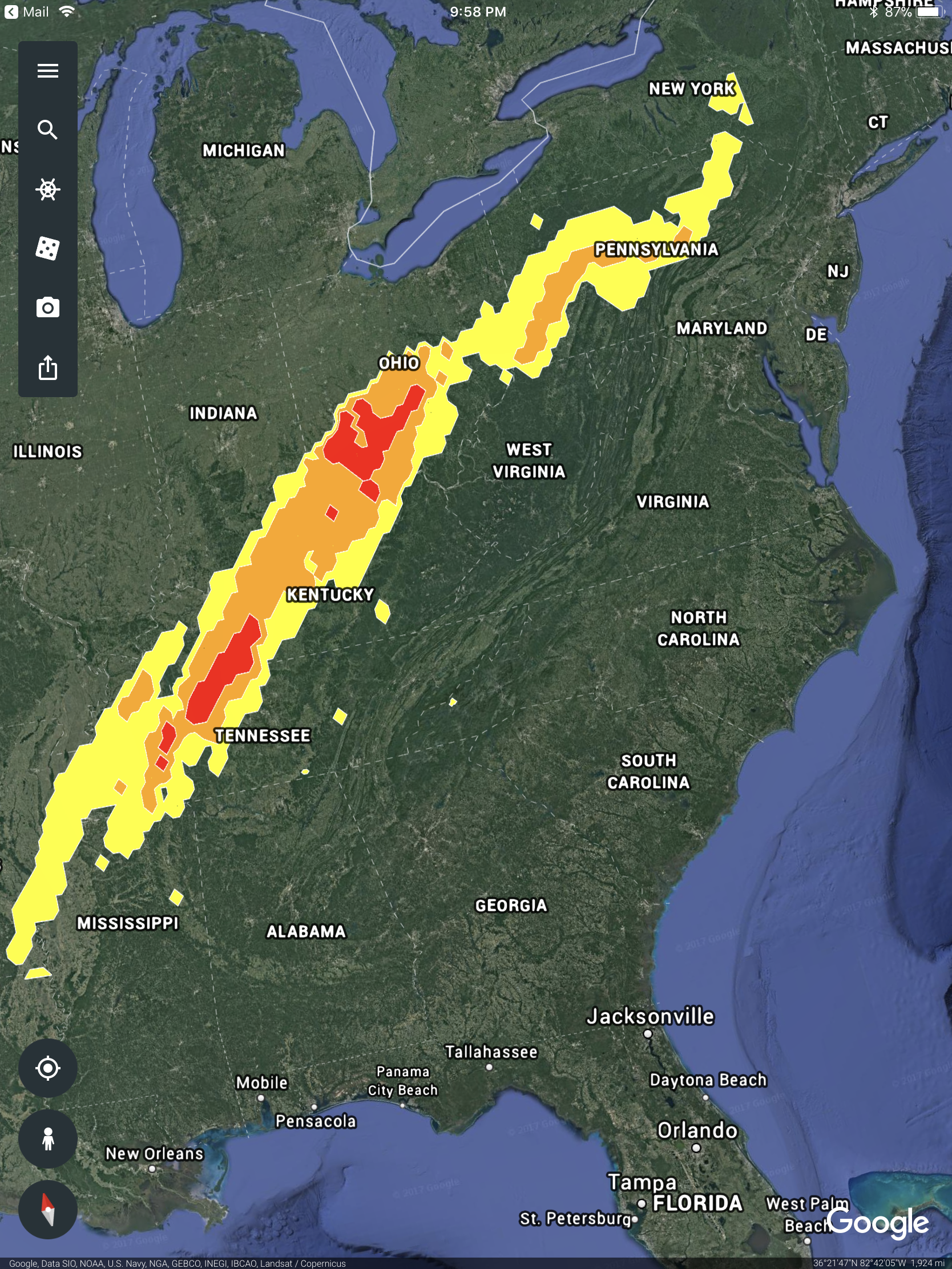
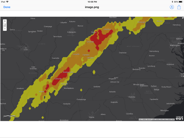
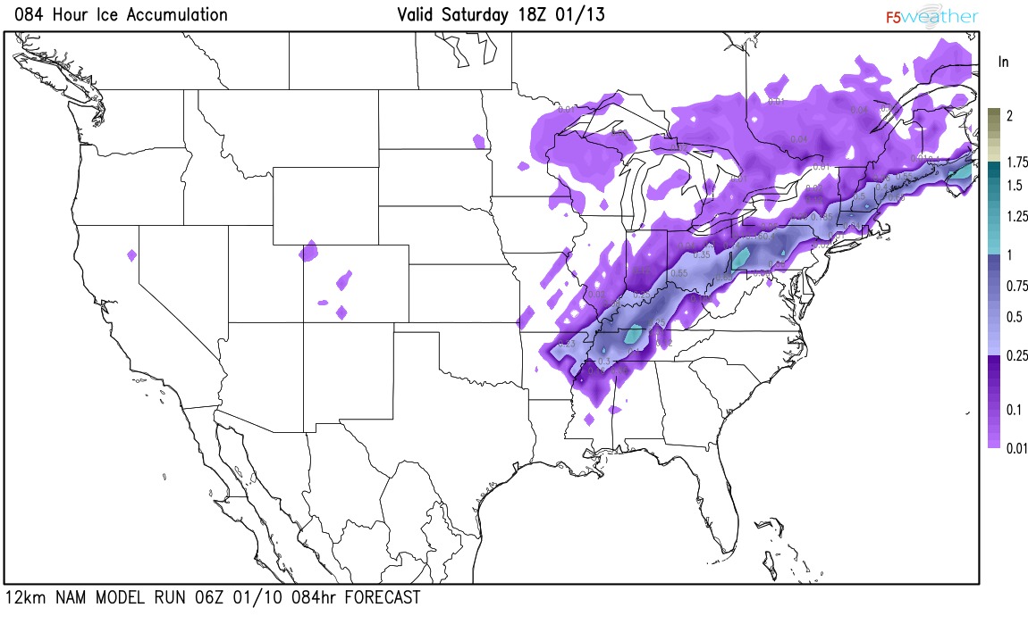
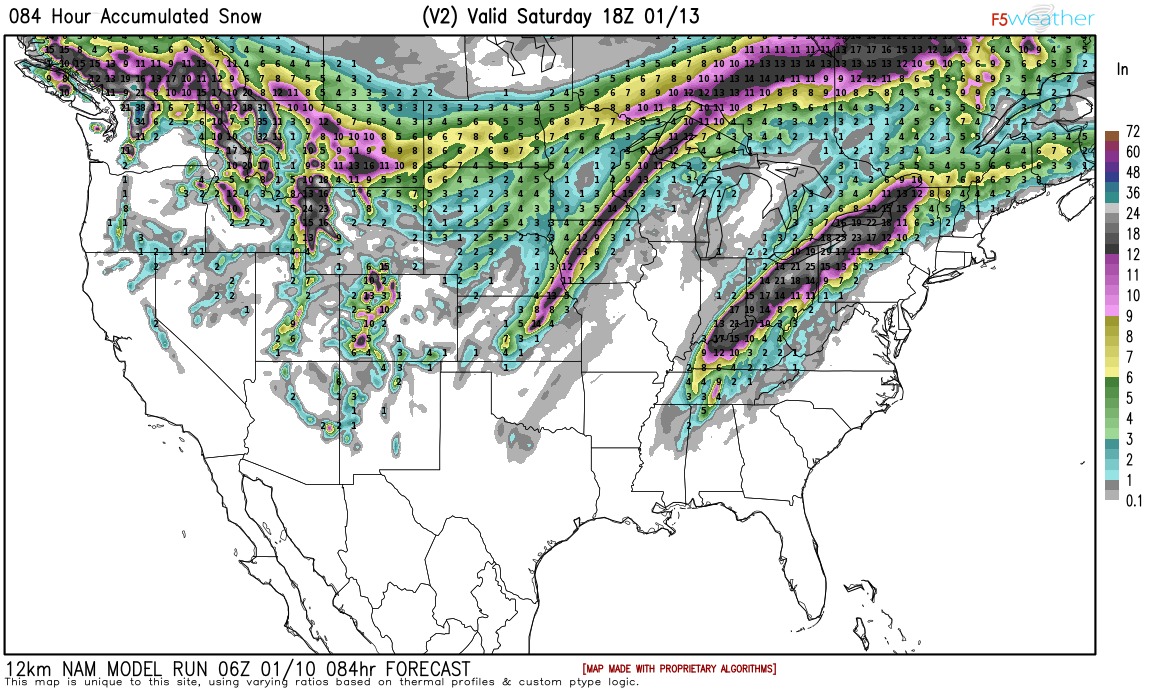
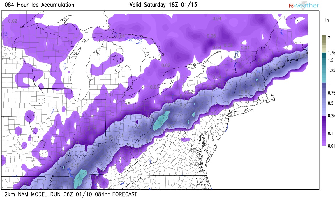
Michigan will be on the call Todd.

Joe McElroy
Director of Safety
Michigan Electric Cooperative Association
201 Townsend Street, Suite 900
Lansing, MI 48933
(517) 331-4459 mobile
(269) 467-7576 office

> On Jan 10, 2018, at 8:20 PM, Todd Blocker <tblocker@tnelectric.org> wrote:
>
> 9:30 AM  CST
> Number: 888-585-9008<tel:888-585-9008>
> Conference Room number: 864-162-890<tel:864-162-890>
> Organizer Pin: 5025786<tel:5025786>
> Todd Blocker | Vice President of Member Relations Tennessee Electric Cooperative Association |
> O: 615.515.5510<tel:615.515.5510> | M: 931.224.0555<tel:931.224.0555>
> tnelectric.org<http://tnelectric.org> | twitter.com/tnelectric<http://twitter.com/tnelectric>  | facebook.com/tnelectric<http://facebook.com/tnelectric>
>
>
> -------- Original message --------
> From: Todd Blocker <tblocker@tnelectric.org>
> Date: 1/10/18 9:10 AM (GMT-06:00)
> To: Sid Sperry <SKSPerry@oaec.coop>, sw-storm-coordinators@feca.simplelists.com
> Subject: Re: Potential large path, multi-state freezing rain followed by moderate to heavy snow event shaping up...
>
> Tennessee will be glad to host a Mutual Aid conference call, how does 9:30 AM CST Thursday sound for everyone?
>
> Todd Blocker | Vice President of Member Relations Tennessee Electric Cooperative Association |
> O: 615.515.5510<tel:615.515.5510> | M: 931.224.0555<tel:931.224.0555>
> tnelectric.org<http://tnelectric.org> | twitter.com/tnelectric<http://twitter.com/tnelectric>  | facebook.com/tnelectric<http://facebook.com/tnelectric>
>
>
> -------- Original message --------
> From: Sid Sperry <SKSPerry@oaec.coop>
> Date: 1/10/18 7:37 AM (GMT-06:00)
> To: sw-storm-coordinators@feca.simplelists.com
> Subject: Fwd: Potential large path, multi-state freezing rain followed by moderate to heavy snow event shaping up...
>
> Will apologize if this is the second time you receive this email. My first attempt earlier this morning was sent from my Sid.Sperry@spidiweather.com<mailto:Sid.Sperry@spidiweather.com> email address, which was not apparently included in this List Serve as an approved email address. (I’ve sent Ray a message asking him to please add that email address to his list.) Thank you all for your patience & understanding!
>
> Sid Sperry
> OAEC
>
> Sent from my iPad
>
> Begin forwarded message:
>
> From: "Sid Sperry" <Sid.Sperry@spidiweather.com<mailto:Sid.Sperry@spidiweather.com>>
> To: "sw-storm-coordinators@feca.simplelists.com<mailto:sw-storm-coordinators@feca.simplelists.com>" <sw-storm-coordinators@feca.simplelists.com<mailto:sw-storm-coordinators@feca.simplelists.com>>
> Cc: "piltz.steve@gmail.com<mailto:piltz.steve@gmail.com>" <piltz.steve@gmail.com<mailto:piltz.steve@gmail.com>>, "Daniel Piltz" <daniel.piltz@spidiweather.com<mailto:daniel.piltz@spidiweather.com>>, "Daniel Piltz" <dpiltz6@gmail.com<mailto:dpiltz6@gmail.com>>
> Subject: Potential large path, multi-state freezing rain followed by moderate to heavy snow event shaping up...
>
> All,
>
> Several models (NAM, GFS, GEM, but not the Euro or ECMWF) are beginning to come into agreement as to the POSSIBILITY of a large path, multi-state freezing rain event, which COULD be followed almost immediately with moderate to heavy snowfall in the same areas impacted by ice.
>
> The states potentially impacted by icing: MS, AR, TN, MO, KY, IL, IN, OH, PA, NY, MA,  VT, NH, and ME. Some icing could occur into northern AL.
>
> At this time, major models and early NWS blended forecasting models indicate ice amounts ranging from 1/4” up to 1.25” in some areas. Snow amounts range from 8” up to 25” in some areas primarily east of the Mississippi River and north of the MS, AL and TN borders.
>
> Late last night, this freezing rain event was being forecasted as a SPIA Index Level 3 event for some areas, using the NAM forecasting model.
>
> Here are some Forecast images. We are keeping a very close eye on this event, which would generally occur from early Thursday morning (MO, IL, KY, AR, TN) through Friday (IN, OH, PA, NY) and into Saturday evening (VT, MA, NH, ME). Please let me know if you have any questions or concerns. - Sid Sperry.  sksperry@oaec.coop<mailto:sksperry@oaec.coop>  OR  Sid.Sperry@spidiweather.com<mailto:Sid.Sperry@spidiweather.com>  OR  SidSperry@gmail.com<mailto:SidSperry@gmail.com>  Cell Phone: 405-627-7754
>
> [cid:4cbd1a8e-6fe1-4d15-bbe6-ebbc79a9a67a@namprd12.prod.outlook.com]
>
>
>
>
> [cid:fdaa3142-bf43-493b-9833-9018a1569269@namprd12.prod.outlook.com]
>
>
>
> [cid:c08f08f4-0efe-4433-b997-0ac736f0b347@namprd12.prod.outlook.com]
>
>
>
> [cid:723bdbe6-1015-4f02-82b3-0012b859be1e@namprd12.prod.outlook.com]
>
>
> [cid:1c1232f1-9f0a-4911-b876-15e4ac167846@namprd12.prod.outlook.com]
>
>
> Sent from my iPad
> <image1.png>
> <image1.png>
> <image1.jpeg>
> <image1.jpeg>
> <image1.jpeg>

 Show/hide attachments