Want to know why this is such a difficult storm to forecast for NWS Forecasters?
Sid Sperry 11 Jan 2018 01:44 UTC
All,
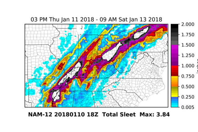
I thought I would share this graphic with you tonight to give you an idea as to why winter storms are SO difficult to forecast for NWS forecasters and other trained, certified, degreed meteorologists.
I’ve mainly sent you graphics showing the freezing rain/ice Forecast, and possible snow forecast. Here is the NAM Model for a SLEET! So, it appears that this event will likely contain all three winter storm ingredients: freezing rain and ice at the storms leading boundary as it moves east-northeast; then a possible HEAVY LAYER OF SLEET (those bright white areas in the middle of the black areas are more than 3” of Sleet/Grauple!); then potentially heavy snow on the ‘backside’ of the storm. This is absolutely a forecaster’s worst nightmare - or, their ultimate forecasting challenge!
Just wanted to share this NAM Model Sleet graphic. I’ll forward NWS forecast images for the Northeast Region, Southeast Region, North Central Region, and South Central Region in a few minutes. Have a good evening, and I’m looking forward to being on the call hosted by Todd at TECA tomorrow.

 Show/hide attachments