Severe Thunderstorm Warning & Severe Thunderstorm Watch this AM, parts KS & MO. Flood Warnings & Flood Watches parts NM, WI, IL, MO, IN & OH. Excessive Heat Warnings, Excessive Heat Watches, and Heat Advisories parts WA, OR, ID, NM, KS, OK, TX, MO, AR, LA, IL, KY, TN, MS, AL, FL, IN, GA, SC, NC, VA, WV, MD, DE, PA, NJ, NY, CT, RI, MA, VT, NH & ME (33 of 50 states). Red Flag Fire Warnings OR & CA.
Sidney Sperry 16 Jul 2024 13:53 UTC
LIMITED Severe Thunderstorm Risk, Day 1 (Tuesday), parts NE, CO, KS, NM, OK, TX and parts OH, WV, VA, MD, DE, PA, NJ, NY, VT, MA & CT. Includes LIMITED High Winds Risk & LIMITED Hail Risk (parts NE, CO, KS, NM, OK & TX).
LIMITED Severe Thunderstorm Risk, Day 2 (Wednesday), parts WV, VA, MD, DE, PA, NJ, NY, CT, MA, VT & NH. Includes LIMITED High Winds Risk.
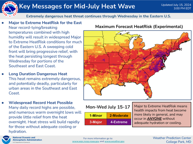
A fairly strong Cold Front is now advancing south-southeast out of Canada and is currently near the northern KS and northern MO borders. It will bring cooler temperatures and some thunderstorms to much of the South Central and Mid-Atlantic states today and Wednesday, then to the Southeast Region states on Thursday and Friday.
- Sid Sperry

 Show/hide attachments