Here is the latest. Fortunately the storm wobbled to the east in the evening and it looks like Glades has largely been spared. They are just beginning their assessment. The others are still being hit but the western peninsula so far is being spared.
From: list-manager@feca.simplelists.com [mailto:list-manager@feca.simplelists.com] On Behalf Of Bill Willingham
Sent: Friday, October 07, 2016 6:25 AM
To: Florida storm-preparation-restoration listserv; managers@feca.simplelists.com
Subject: 6:00 report - Tropics Update: Friday Morning on Hurricane Matthew and Hurricane Nicole***
Importance: High
From: Florida Division of Emergency Management [mailto:FDEM@public.govdelivery.com]
Sent: Friday, October 07, 2016 6:12 AM
To: fecabill@embarqmail.com
Subject: ***FYI: Tropics Update: Friday Morning on Hurricane Matthew and Hurricane Nicole***
This update is intended for government and emergency response officials, and is provided for informational and situational awareness purposes only. Forecast conditions are subject to change based on a variety of environmental factors. For additional information, or for any life safety concerns with an active weather event please contact your County Emergency Management or Public Safety Office, local National Weather Service forecast office or visit the National Hurricane Center website at www.nhc.noaa.gov. You are subscribed to Tropics Briefing Packages for Florida Division of Emergency Management. This information has recently been updated, and is now available.
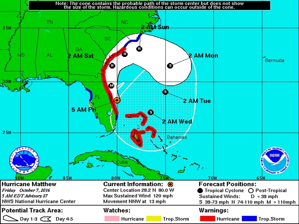
Tropical Summary: •At 5am EDT, Hurricane Matthew is located approximately 40 miles east southeast of Cape Canaveral, FL. •Maximum sustained winds are currently 120 mph with higher gusts, making Matthew a Category 3 hurricane on the Saffir-Simpson scale. •Matthew is moving toward the north northwest at 13 mph, and this general motion is expected to continue today. a turn toward the north-northwest is expected on Friday, and a turn toward the north expected Friday night or Saturday. A turn toward the north is expected tonight or Saturday. On the forecast track, the center of Matthew will be moving near or over the east coast of the Florida peninsula through tonight. •It is important not to focus on the center line of the forecast cone. Only small deviation in the forecast track to the left could bring the core of a major hurricane onshore, while a small deviation to the right could keep all of the hurricane-force winds offshore. •Matthew remains a large storm, with tropical storm force winds extending 185 miles from the center, and hurricane force winds extending 60 miles from the center. •There is uncertainty in the forecast track for Matthew beyond 48 hours. The official forecast calls for Matthew to turn southeast and then southwest, taking Matthew back toward the Bahamas as a tropical storm. •The latest model track guidance favor this scenario, but this could certainly change over the next few days. •At 5am EDT, Hurricane Nicole is located is approximately located 345 miles south of Bermuda. Nicole is drifting southward, and a slightly faster southward motion is expected tonight and Saturday. Nicole is a Category 2 hurricane with maximum sustained winds of 100mph. Florida Outlook: •Hurricane Warning is in effect for Volusia, Brevard, Orange, Seminole, Osceola, Okeechobee, Indian River, Martin, St. Lucie, Nassau, Duval, St. Johns, Flagler, Putnam, and Clay Counties, including Lake Okeechobee. •Tropical Storm Warning is in effect for Palm Beach, Highlands, Hardee, Polk, Lake, Sumter, Marion, Alachua, Union, Bradford, Baker, Columbia, Levy, Citrus, Hernando, and Pasco Counties. •Tropical Storm Watch is in effect for Hillsborough, Pinellas, Desoto, and Manatee Counties. •Flood Watch is in effect for Baker, Bradford, Union, Nassau, Duval, St. Johns, Flagler, Clay, Putnam, Volusia, Brevard, Indian River, Martin, Okeechobee, Orange, Osceola, Seminole, St. Lucie, and Palm Beach Counties. •Regardless of track, Matthew is a very large storm and will generate tropical storm force winds and rough seas along the East Coast of Florida, along with minor coastal flooding, beach erosion, and dangerous rip currents. •Hurricane conditions are currently affecting Brevard County and will continue to move northward along the east coast of Florida. Any deviation from the track could bring these destructive hurricane winds further inland. •An Extreme Wind Warning is in effect in Northeast Brevard County for Cape Canaveral until 7:15 AM EDT. Extreme winds associated with the eyewall of Hurricane Matthew are moving onshore and can produce frequent gusts of 115mph or greater. This is an extremely dangerous and life-threatening situation. •Tropical storm conditions will continue to spread northward in the warning area along the East Coast and over many inland areas tonight and tomorrow. •The current forecast calls for 8-12” of rain along the east coast of Florida with isolated totals of 15” possible. •Storm surge values of 7-11’ is possible from Sebastian Inlet north through Nassau County, including the St. Johns River. Storm surge values of 4-6’ is also still possible from Sebastian Inlet to Jupiter Inlet. •The combination of a dangerous storm surge and the tide will cause normally dry areas near the coast to be flooded by rising waters moving inland from the shoreline. There is a danger of life-threatening inundation during the next 24-36 hours along the Florida east coast from Brevard to Nassau County. •An isolated tornado or two is possible along the East Central Florida coast today. •Hurricane Nicole does not pose a threat to Florida. Another briefing packet will be issued on Friday at noon. For more information on this system, please visit the NHC website at www.nhc.noaa.gov
|