|
This update is intended for government and emergency response officials, and is provided for informational and situational awareness purposes only. Forecast conditions are subject to change based on a variety of environmental factors. For additional information, or for any life safety concerns with an active weather event please contact your County Emergency Management or Public Safety Office, local National Weather Service forecast office or visit the National Hurricane Center website at www.nhc.noaa.gov.
You are subscribed to Tropics Briefing Packages for Florida Division of Emergency Management. This information has recently been updated, and is now available.
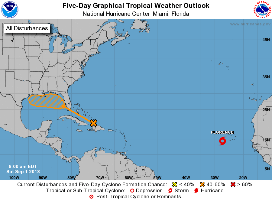
•Tropical Storm Florence has passed the Cabo Verde Islands and is on its way into the open Atlantic.
•Maximum sustained winds are near 45 mph, and gradual strengthening is forecast through the next several days.
•This system is expected to have no impact on land.
•A tropical wave near Hispaniola is producing disorganized cloudiness and thunderstorms.
•This tropical wave is currently weak and disorganized but will move west-northwest towards the Bahamas and South Florida Sunday and Monday and into the eastern Gulf of Mexico early next week.
•Development is not expected to occur in the Caribbean or western Atlantic, but environmental conditions might become slightly more favorable for possible development in the eastern or central Gulf of Mexico.
•The National Hurricane Center has a 10% chance of formation over the next 2 days. Development chances in 3-5 days are at 40%. The increase in development chances is due to the inclusion of Wednesday in the 5-day outlook and for the possibility of the wave moving farther west over the Gulf of Mexico, having more time to possibly develop.
•No additional tropical cyclone development is expected in the Atlantic basin through the next five days, but additional tropical waves are forecast to emerge off the west Africa coast in the 6-10 day timeframe.
Florida Outlook:
•No impacts to Florida or the Caribbean islands are expected from Tropical Storm Florence.
•The tropical wave near Hispaniola and Puerto Rico will bring increased rain chances to Florida this weekend and through the middle of next week. Regardless of development, locally heavy rainfall will be the main impact from this system.
•Rainfall totals will depend on the exact track and strength of this wave, but most areas should receive 1-3” of rain over the next 5-7 days with isolated higher amounts of 4-6” possible.
•7 West-Central Florida rivers remain in minor flood stage, and many rivers across the state are elevated due to recent rainfall, but significant river flooding is not currently expected.
•This wave, along with potential rain amounts and impacts, will continue to be monitored.
•There will be a high risk of rip currents for Panhandle and East Coast beaches through the next several days.
•Even if this wave develops, the current track consensus would keep any wind impacts offshore away from Florida.
Another briefing packet will be sent out Sunday morning. For the latest information on the tropics, please visit the National Hurricane Center website at www.hurricanes.gov.
|